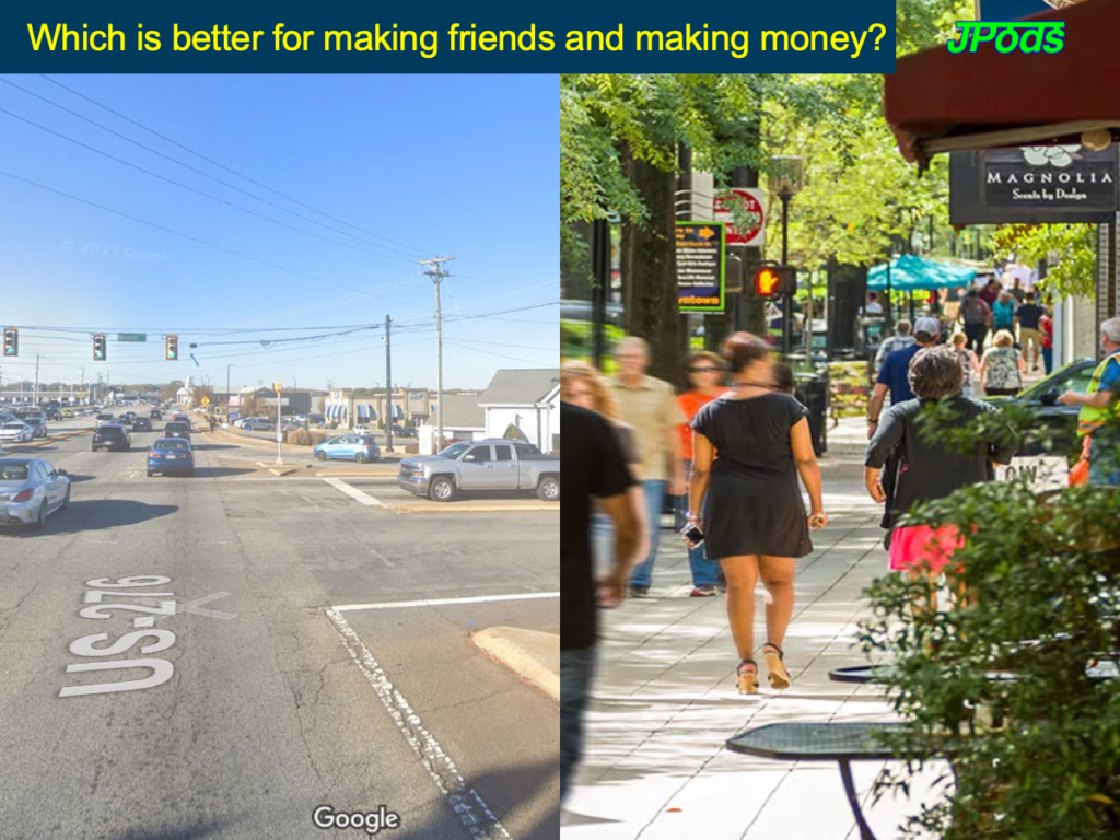
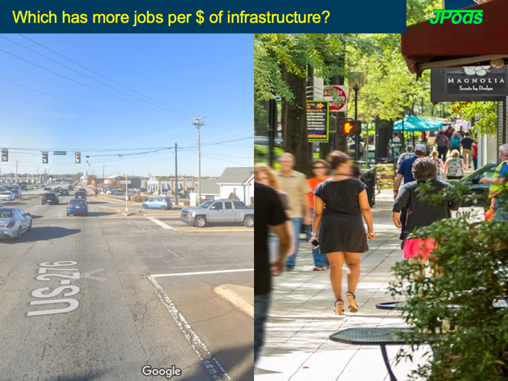
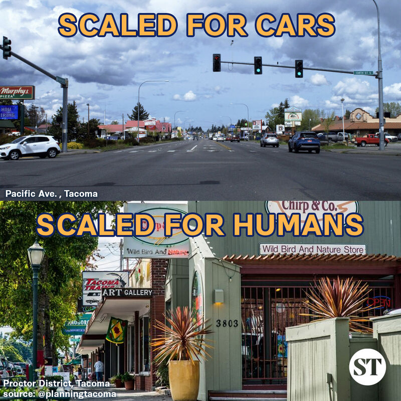
Two aspects of a city, car-centric and walkable. Ask some questions of yourself.
- Commerce and community are pedestrian activities.
- AI prompts to evaluate your city’s data.
Eisenhower stated that the concept of running Interstate routes through congested parts of cities was “entirely against his original concept and wishes”. Eisenhower Library and other Bragdon Committee data. Federal highways are unconstitutional.
Walkable Score and ai assessment of increased walkable score with JPods networks.
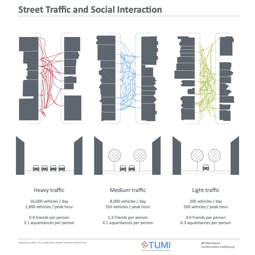
Importance of bikes to cut car use by 60%.
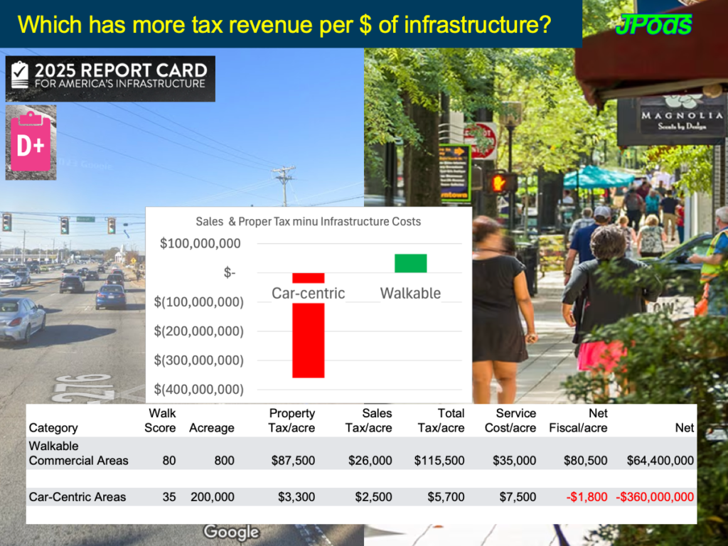
Suburbia is Subsidized: Here’s the Math
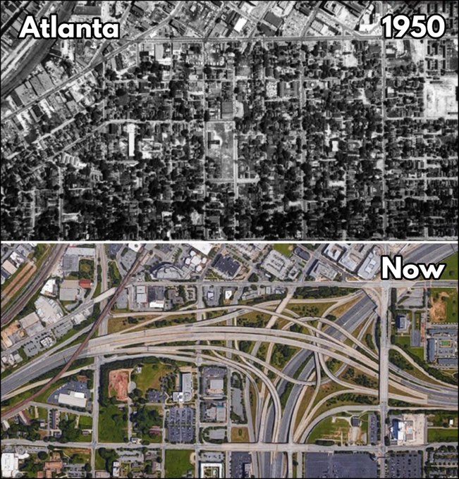
How Highways Wrecked American Cities
Below are detailed references to the harms unconstitutional Federal highways have caused American cities following World War II.
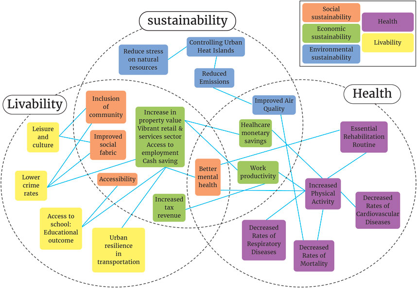
Metrics of walkable value:
- Price premiums: Walkable urban areas command 35-45% higher rent or sales prices for office, retail, rental housing, and for-sale housing compared to drivable suburban areas (link).
- Market share growth: All 35 metropolitan areas studied saw walkable urban places gain market share at 2.8 times their 2017 levels (link).
- Land efficiency: Only 1.2% of land mass in the largest 35 US metropolitan areas are walkable urban areas, yet this tiny fraction generates nearly 20% of US GDP (link).
- Job concentration: Approximately one-third of all jobs in the top 35 metros are located in significant walkable urban places (link).
- Educational attainment: In the top six walkable urban metro areas, 42% of the workforce has a college degree, compared to 31% in the seven lowest-ranked areas (link).
- GDP per capita: The six most walkable metro areas have a 52% higher GDP per capita than the seven lowest-ranked areas (link).
- Property values: Each additional Walk Score point is associated with an increase of between $500 and $3,000 in home values (link).
- Local government revenue: In Arlington, Virginia, 10% of the county’s land mass converted to high-density walkable urban places now generates more than 50% of tax revenues, up from 20% 30 years ago (link).
Health metrics
- Physical Activity: Adults living in walkable neighborhoods are 1.5 times more likely to engage in adequate levels of physical activity compared to those in less walkable areas6.
- Obesity Rates: Residents of highly walkable neighborhoods are 0.76 times less likely to have obesity compared to those in low walkability areas6.
- Cardiovascular Disease: Prevalence of cardiovascular disease is 5.4% in the most walkable neighborhoods compared to 7% in the least walkable areas4.
- Chronic Conditions: About 30% of adults in the most walkable neighborhoods have high blood pressure, high cholesterol, or obesity, compared to 36% in the least walkable neighborhoods4.
- Diabetes: Type 2 diabetes prevalence is 10.6% in the most walkable neighborhoods versus 11.6% in the least walkable areas4.
- BMI Levels: Higher neighborhood walkability is associated with lower BMI levels across various racial/ethnic groups, except for American Indian/Alaska Native and multiracial/other adults8.
Federal Harm to Cities
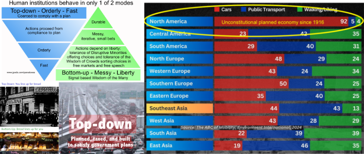
There are two paths have been followed by people seeking power, evolving two distinct types of goverments (Cities and the Wealth of Nations, Jane Jacobs):
- Nations evolved from “hunting and raiding”.
- “Supreme power to coerce, a monopoly of violence within a territory.” Francis Fukuyama
- “Violence monopoly of the state”, Max Weber
- “War made the state, and the state made war.” Charles Tilly
- Cities evolved from “making and trading.”
- Division of labor requires movement of goods between points of value added.
- Cities evolved to be walkable to minimize the energy required to transport goods between points of value added.
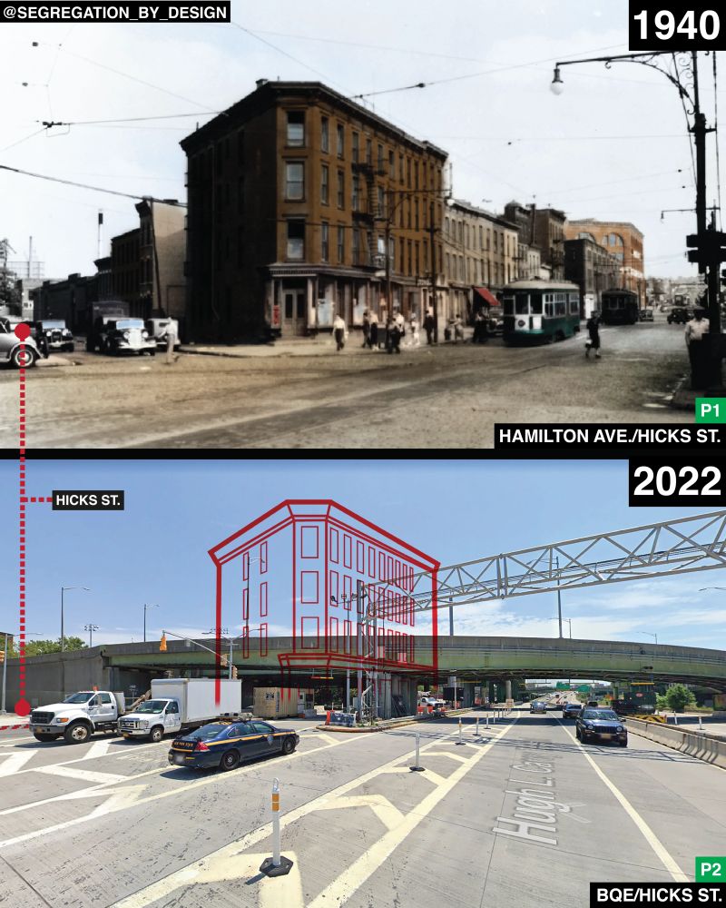
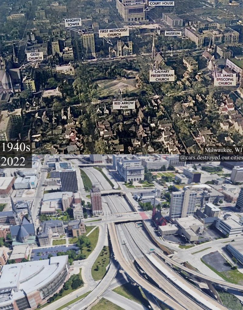
After World War II, national government retooled cities with based on their nature of “hunting and raiding.” The National Interstate and Defense Highways Act, or Federal-Aid Highway Act of 1956. Build the Interstate Highway network.
Harms to national defense:
- These highways, and their impact of military planning, harmed national defense. The US war record since 1956 is zero wins and three losses. Federal highways created foreign oil addiction, funded terrorists with oil-dollars, funded enemies to wage war on American with oil-dollars.
- The Bragdon Committee: “In the late fifties, General J. S. Bragdon, working for the President, made some very serious charges against the Bureau of Public Roads’ (BPR) stewardship of the Interstate highway program and recommended far-reaching changes in the program. Among other things, he recommended an Interstate toll program, a cut-back in urban mileage, and a moratorium on all urban projects until a comprehensive planning process was established.”
- Top-Down planning based on “raiding and trading” is harmful to national defense, cities, and people.
Harms to families
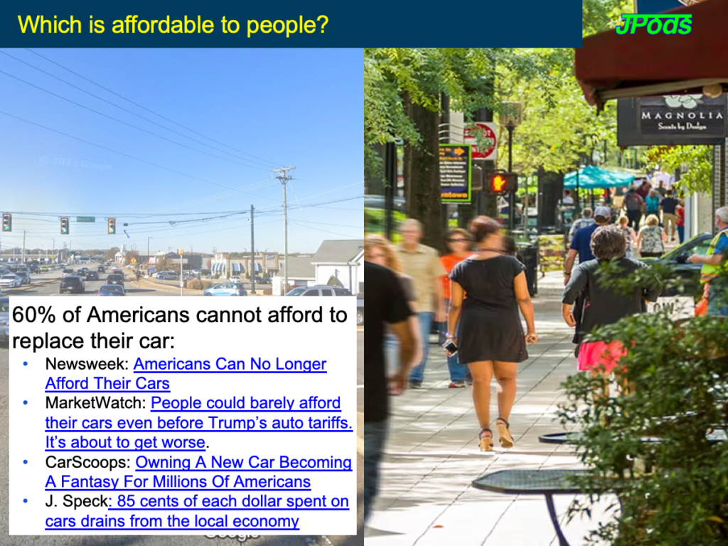
- Car costs a family about $12,182, is parked 95% of the time with ~85% of car costs leaving the local economy. 2.24 cars per household (278.06 million cars, 124.01 million households) 4.6 tons of CO2/car/year
- Study: How Car Ownership is Keeping Americans From Financial Stability
- Newsweek: “Americans needed an annual income of at least $100,000 to afford a car. That means that more than 60 percent of American households currently cannot afford to buy a new car. For individuals, the numbers are even worse, with 82 percent of people below the $100,000 line”
- How Forgiving design in roads kills pedestrians
- Importance and harms to bikes.
- Racist outcomes, Federal highway construction replaced Jim Crow.
- In 1974, nearly a third of Americans reported spending time with their neighbors at least twice a week. Forty years later, that number had been cut in half. Over the same period of time, the number of Americans reporting zero interactions with their neighbors has grown from 20% to almost 35%
Harms to cities
- Walkable cities were segmented by Interstate Highways. Only 1.2% of land area in the 35 largest US cities remains walkable, yet they generate 20% of GDP.
- How to design business park, Business Parks Suck (but they don’t have to)
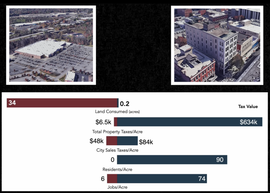
- City ROI by type of design: Here’s the Math [ST07] (10 minute video) Excellent video
- CNBC: How Suburban Sprawl Weighs On The U.S. Economy
- 2:15 Federal rules
- It’s Time To Rethink How We Measure Cities. We Can’t Afford Not To.
- How Suburban Development Makes American Cities Poorer [ST02]
- Why American Cities Are Broke – The Growth Ponzi Scheme [ST03]
- How Bankrupt American Cities Stay Alive – Debt [ST04]
- 2:15 Brainerd, MN 1890 to today. Bull dozed for the car. Paid for by Federal debt.
- 9:00 Crisis in family debt.
- 9:30 Cities were built by many people making small bets with 20:1 to 40:1 private versus public risk.
- ASCE rates US highways a “D”

Why designing to make walking safe makes driving better
Transit needs walkable destinations;
- Not Just Bikes and Strong Towns Discuss Public Transit in North America
- In 1902 every American city of greater than 10,000 people had a streetcar system. Wikipedia list of US streetcar systems.
- 33:00 Transit plan without a land use plan is a waste of time and money. Land use plan without a transit plan is a lost opportunity.
- 37:00 talks about what JPods networks provide. Connection between walkable spaces. Connect islands.
- 39:00 no neighborhood should be exempt from change and no radical change applied. Tinker, versus plan.
- America Always Gets This Wrong (when building transit).
- This is an excellent summary of how the parking engineers responsible for sprawl make unwalkable transit.
- 10-15 minute walk-shed
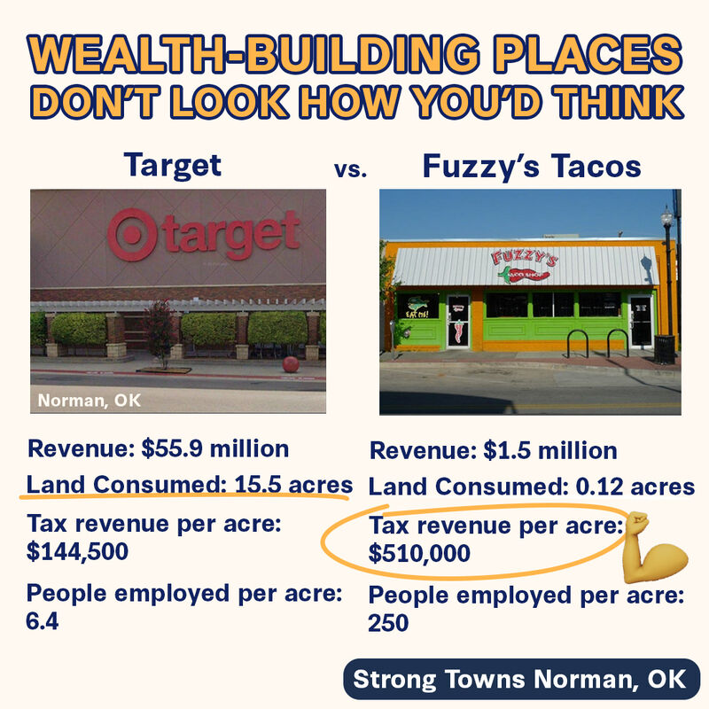
- Suburbia is Subsidized: Here’s the Math [ST07]
- ROI based on value per acre
- 3:16 Layfayette P&L Map
- 4:10 River Ranch, walkable community
- $1,500 to $9,200 per year tax increase to pay for sprawl
- 5:13 poor neighborhoods are subsidizing wealthy neighborhoods
- 6:00 Eugene, OR mixed use community
- 7:30 South Bend, IN
- 7:40 Charleston, SC
- 7:42 St Paul, MN
- 8:19 Revenue along transit lines.
- 9:00 Guelph, Canadian city focusing on infill development 2013, 2016, 2019
- The Houses that Can’t be Built in America – The Missing Middle
- How Bankrupt American Cities Stay Alive – Debt [ST04]
- 2:15 Brainerd, MN 1890 to today. Bull dozed for the car. Paid for by Federal debt.
- 9:00 Crisis in family debt.
- 9:30 Cities were built by many people making small bets with 20:1 to 40:1 private versus public risk.
- Stroads are Ugly, Expensive, and Dangerous (and they’re everywhere) [ST05]
- Introduction to the 85th Percentile Speed The Wrong Way to Set Speed Limits [ST06]
- minute 9:30. If drivers average higher than the purpose speed, change the design of the street to communicate to driver instincts the correct speed.
- Suburbia is Subsidized: Here’s the Math [ST07]
- ROI based on value per acre
- 3:16 Layfayette P&L Map
- 4:10 River Ranch, walkable community
- $1,500 to $9,200 per year tax increase to pay for sprawl
- 5:13 poor neighborhoods are subsidizing wealthy neighborhoods
- 6:00 Eugene, OR mixed use community
- 7:30 South Bend, IN
- 7:40 Charleston, SC
- 7:42 St Paul, MN
- 8:19 Revenue along transit lines.
- 9:00 Guelph, Canadian city focusing on infill development 2013, 2016, 2019
- The Houses that Can’t be Built in America – The Missing Middle
- The Trains that Subsidize Suburbia – GO Transit Commuter Rail.
- 3:30 This highlights the defect of building JPods networks to service 9-5 business parks.
- 4:10 Hub and spoke design
- 6:50 No walkable end points
- 15:00 Colossus waste of money.
- How Toronto Got Addicted to Cars
- 5:20: Jane Jacobs quote
Strong Towns
- Why Bad Street Design is Both Costly and Deadly
- This Ponzi Scheme Might END Suburban Prosperity
- We Keep Losing The Battle Against Traffic. Is This Inevitable?
- To long to get where you want to go, half hour
- Travel time is too variable and uncertain
- Getting where you want is miserable.
- Retrofitting suburbia, Ellen Dunham-Jones, TEDxAtlanta
- How public spaces make cities work, Amanda Burden, TED
- 4 ways to make a city more walkable | Jeff Speck
- 8:40 double the block size quadruple the fatal injuries.
- 10:30 Oklahoma City
Streetcars
- Vox: The real story behind the demise of America’s once-mighty streetcars
- There were 17,000 miles of streetcar lines across the country, running through virtually every major American city
- Streetcars, A History
- By 1902, some 15,000 miles were in service across the country (accounting for 97% of all such operations), an astounding jump of 70% in only twelve years.
- The Trolley and Daily Life
- Britannica: streetcar
- Wikipedia list of US streetcar systems
The Outsized Cost of Expanding US Roads
When Climate Funds Pay for Highway Expansion
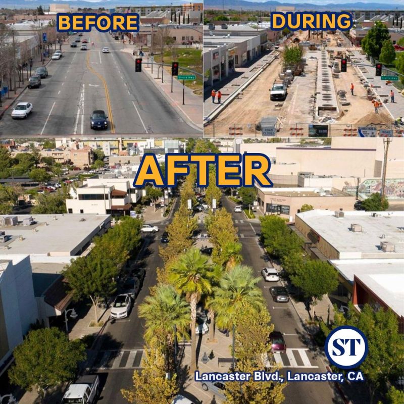
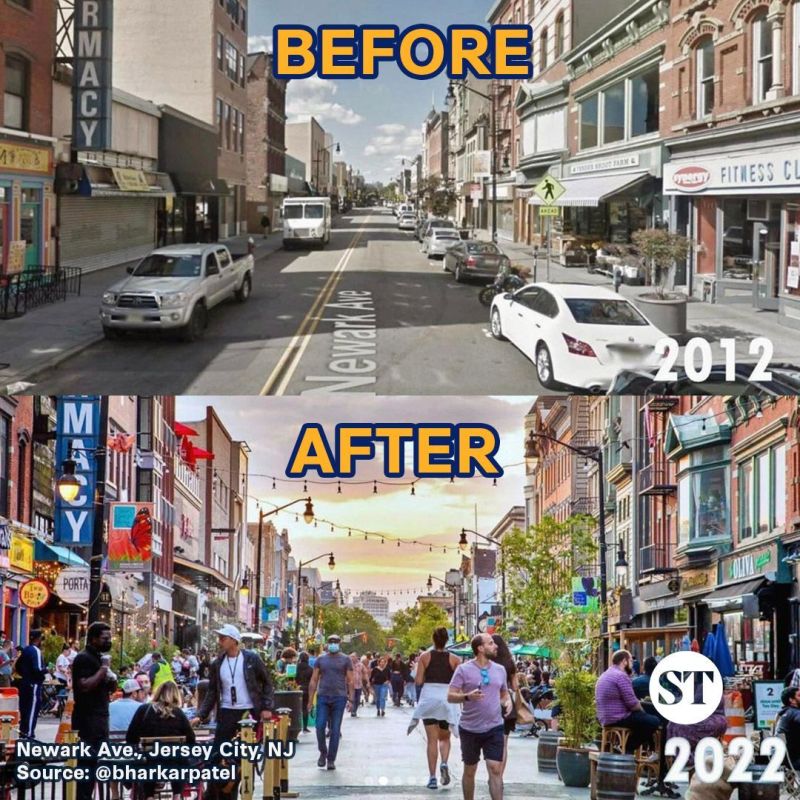
Unconstitutional Federal highways making unwalkable cities.
<iframe src=”https://ourworldindata.org/explorers/energy?tab=chart&time=1965..2023&hideControls=true&Total+or+Breakdown=Select+a+source&Energy+or+Electricity=Primary+energy&Metric=Per+capita+consumption&Select+a+source=Oil&country=USA~DNK~SWE” loading=”lazy” style=”width: 100%; height: 600px; border: 0px none;” allow=”web-share; clipboard-write”></iframe>
Hannah Ritchie and Pablo Rosado (2017) – “Fossil fuels” Published online at OurWorldinData.org. Retrieved from: ‘https://ourworldindata.org/fossil-fuels‘ [Online Resource]
https://usa.streetsblog.org/2020/10/10/exactly-how-far-u-s-street-safety-has-fallen-behind-europe-in-four-bombshell-charts
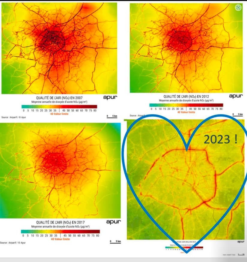
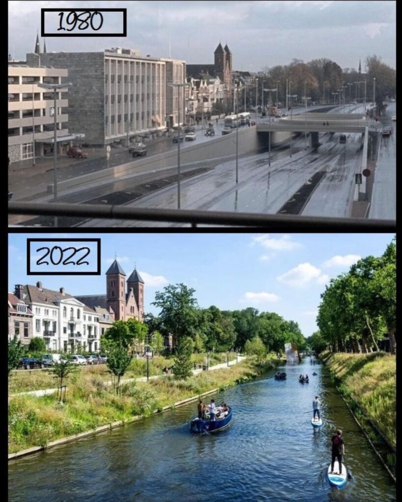
Link to radical improvement in Paris commerce, community, and health.
Tar and Cement song. Paved Paradise – Big Yellow Taxi